Perhaps you wonder about when the home was built, who built it, and the lives of the many people who’ve lived there.
If so, this is the perfect project for you!
Together we’ll delve into the lives of some remarkable Ottawa homes, thanks to David LaFranchise and Marc Lowell of House History Ottawa. Their in depth research on Ottawa’s many historical homes opens the doors to this city’s fascinating past.
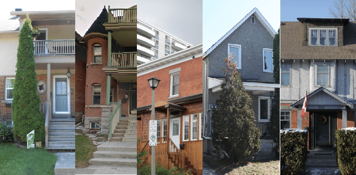
House History Ottawa has been chronicling the histories of Ottawa’s old homes for decades. In this exhibit, we share a slice of the wealth of information that they have dug up over the years. Focusing on five homes in Ottawa’s Lower Town, we’ll explore a variety of residences, not only structurally but also in each home’s unique history.
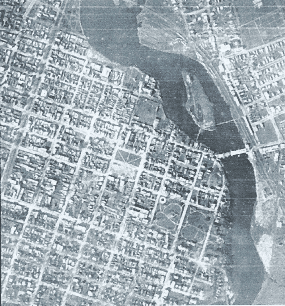
When Lieutenant-Colonel John By of the Royal Engineers arrived at the Chaudière Falls in 1826 to begin construction of the Rideau Canal, many people were convinced that a settlement at the portage around the Chaudière would become an important commercial centre, controlling the growing trade of both the Ottawa River and the Rideau Canal. Promoters had already laid out townsites on both sides of the Ottawa River at the Falls, while the government of Upper Canada had, in 1823, bought the high land south of the river from its absentee owner (lot B in Concession B and lots B and C in Concession C, Rideau Front of Nepean Township, roughly the area bounded by the Ottawa and Rideau Rivers, and today’s Bronson Avenue, Wellington Street, Rideau Street and Cathcart Street) (Elliot 1991 p 15ff).
By took ownership of the government land for the Board of Ordnance, the arm of the British Government in charge of military installations, chose a site for a fortress and laid out a townsite around it, part on the higher ground west of the route of the Canal (Uppertown) but the commercial core on the lower ground east of the Canal (Lowertown). The Board kept ownership of the land, but leased out individual building lots.
By planned the area east of King Street (today’s King Edward Avenue) as a neighbourhood for senior military officers and wealthy merchants. Large lots faced streets and squares with elegant names, including Clarence for the King’s brother William, Duke of Clarence (later King William IV); Charlotte, for the King’s daughter Charlotte Augusta, Princess of Wales; Wurtemburg, for the King’s eldest sister Charlotte, Queen of Wurtemburg; and Parry and Franklin for Sir William Parry and Sir John Franklin, admirals and arctic explorers. At the time, the search for the Northwest Passage was a priority for the Royal Navy, and arctic explorers were celebrities.
When the City moved in the 1870s to number houses and clear up duplicate street names in preparation for house-to-house mail delivery, Clarence, Parry and Franklin Streets, more or less in a line, were consolidated as Clarence. Heney Street, formerly just a lane along the edge of the cemeteries, was also named for John Heney, landowner, businessman and alderman, about this time.
Prosperity and growth by-passed nascent Bytown: the proposed fortress was cancelled, and the commercial importance of the Ottawa River was already in decline when By arrived. Ottawa began to grow quickly in the 1850s, however, when a free trade agreement encouraged the export of softwood lumber to the United States, and the Provincial government voted to move the capital to Ottawa (1858, although the actual move from Quebec City did not take place until 1865).
Even so, the streets in the eastern part of Lowertown remained empty. The public blamed legal problems over the Board of Ordnance’s title to the property and the confused administration of its leases. But even after 1859, when the Board transferred ownership of the Canal and the townsite to the Province of Canada and the Province moved quickly to settle the leases and put the lots up for sale, there were few takers.
In an era when walking was the only means of transport for all but the farmer and the very rich, and roads were very poor, Lowertown East was just too far away from the new mills at the Chaudière and the Rideau Falls. Further, low areas were impassable hemlock swamp, cut by streams draining the hills, while the higher pine-clad hills turned to loose blowing sand as soon as the trees were felled. Both the Board and the Province were reduced to letting the land in large 2-3 acre lots to farmers and market gardeners, and to looking the other way at squatters who simply harvested the timber and occupied the land without any legal title.
Most of the lots remained unsold when the Federal government assumed ownership at Confederation. Bytown did not become the military and commercial centre that By anticipated. When the town finally began to grow in the 1850s, both rich and poor chose to live near the new mills at the Chaudière and the Rideau Falls, or on the high ground to the south and west. By contrast the lower parts of the east end of Lowertown remained impassible hemlock swamp cut by streams, while the surrounding pine-clad hills quickly turned to loose blowing sand once the trees were felled. Tenant farmers or squatters grew vegetables, cut the timber or quarried sand (Elliott 1991, p 93).
To learn more about other Ottawa neighbourhoods and their many residences, you can visit House History Ottawa’s website.
David LaFranchise and Marc Lowell can be reached at [email protected]